|
Medieval visitors at Kouklia Following the end of the Late Antiquity and the abandonment of Palaepaphos' sacred structures, the area became an agricultural community. The ancient monuments asserting the polity's illustrious past were gradually turned into ruins. However, the fame of the monumental Sanctuary of the Paphian Goddess, inextricably associated with the polity remained known for hundreds of years after the abandonment of the archictural monuments and cultic activities. The exact location of the Paphian Sanctuary was unknown, and often Medieval pilgrims misinterpreted the ruins at Saranda Kolones at Nea Paphos as the famous Sanctuary. It was only during the 16th century AD, when the Swiss traveller Ludwig Tschudi (in 1519) and independently the Venetian traveller Francesco Attar (in 1540), who realized that the famous Sanctuary of Aphrodite mentioned in the ancient sources, was located at the agricultural community at the village Kouklia. The visible monuments reminiscent of Palaepaphos' glorious past often recur in the memoirs of western travellers who visited Cyprus in the course of the 19th century, either as educated voyagers or as pilgrims on their way to the Holy Lands. Their written work provides descriptions and often drawings of the standing monuments or visible ruins. An Austrian traveller, Joseph Hammer von Purgstall, who visited Kouklia in 1802, described the remains of the Sanctuary and the visible blocks of the temenos wall. He also provided a drawing of the area. Von Purgstall also visited a large Late Classical rock-cut chamber tomb at the locality of Arkallon, known as the Spilaion tis Regainas, where he transcribed two lapidary inscriptions mentioning Echetimos and Timocharis, the names of two kings of Late Classical Paphos. This large chamber tomb consists of a long dromos, lined with square limestone blocks that leads to a flight of two rectangular main chambers. Each chamber is provided with four smaller side chambers which served for the actual burials. The second main chamber gives on to another roughly square chamber. The two inscribed stones were transferred to the Louvre in 1862 by the French Count de Vogüé. In 1806, the Spaniard Domingo Badia y Leiblich, who is better known by the alias Ali Bey al Abbassi created the first drawing of the Sanctuary's plan and elevation. |
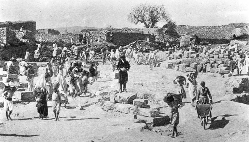
| The earliest archaeological excavations at Kouklia: The "Cyprus Exploration Fund" (1888)
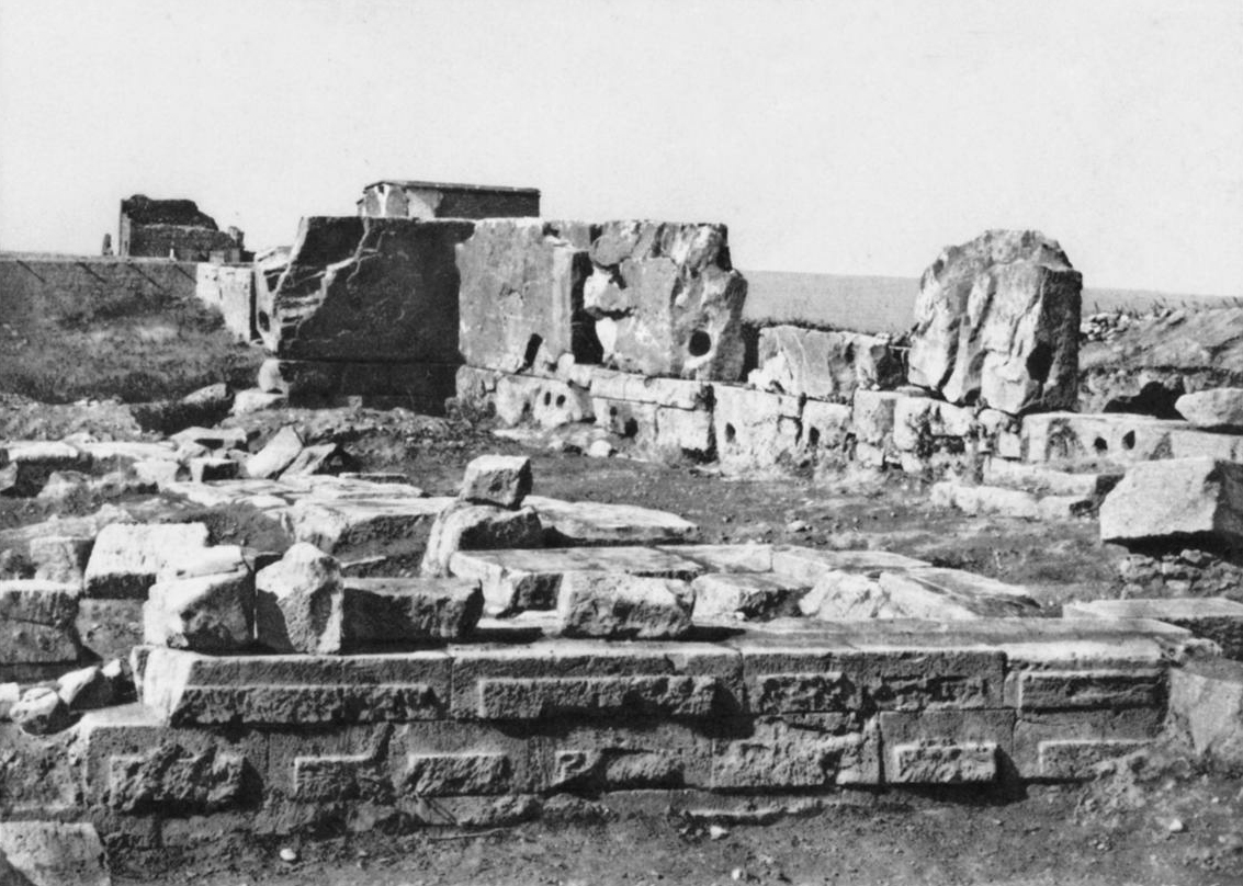
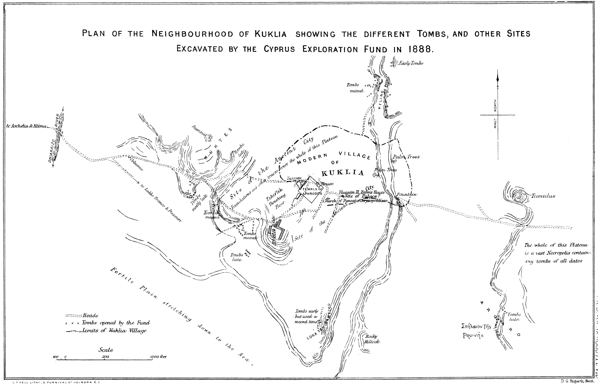
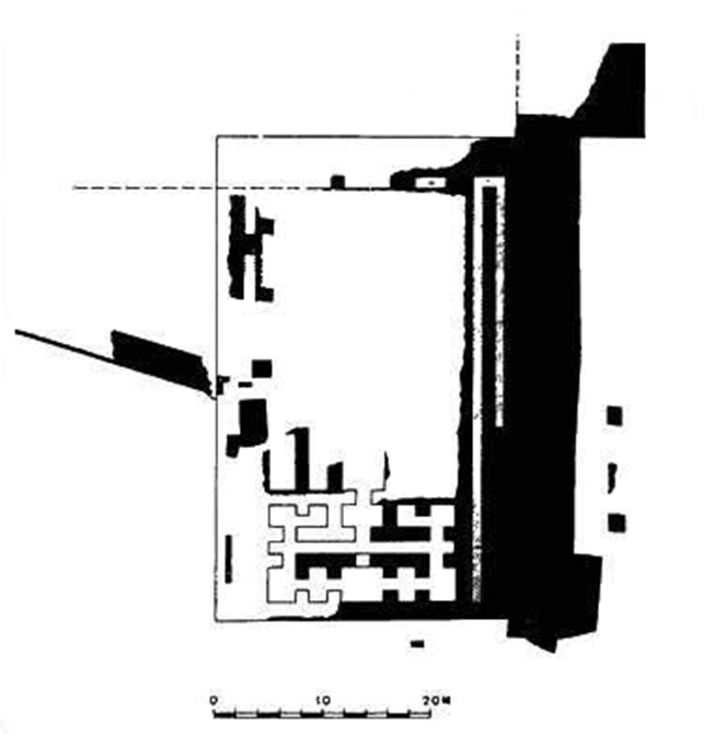
Limited investigations in the area of Kouklia were undertaken by Luigi Palman di Cesnola, the Italian general who served in Cyprus as the American Consul during the late 19th century. Cesnola visited the village of Kouklia during the years 1869, 1874 and 1875, aiming to locate the site of the infamous Paphian Sanctuary. The earliest organized archaeological excavations at Kouklia were undertaken by the Cyprus Exploration Fund in 1888. The Mission, which was directed by E.A. Gardner, the Director of the British School at Athens, conducted large-scale excavations in a number of sites in Cyprus. At Kouklia, the Cyprus Exploration Fund focused on the area of the Sanctuary, and revealed large structures spanning the different stages of its life. Some segments of the Sanctuary that were recorded in 1888, such as the colonnaded hall, are now entirely missing. The preliminary report of the Cyprus Exploration Fund, published in the Journal of Hellenic Studies in 1888 provides invaluable information. In addition to the Sanctuary area, the Cyprus Exploration Fund also investigated a number of other archaeological sites at Kouklia, namely the so-called Spilaion tis Regainas tomb at Arkallon, the cemeteries of Xylinos and Piadhes, the tumulus at Laona, and the wider area of Evreti-Asproyi. Relevant publications:
|
 |
 |
 |
|
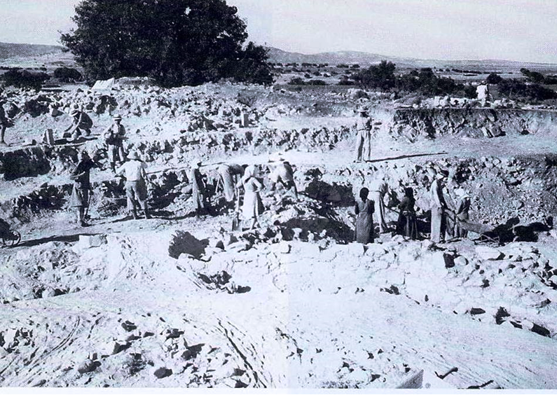
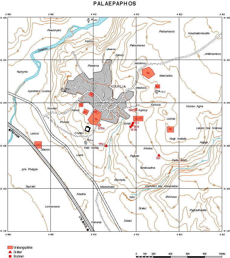
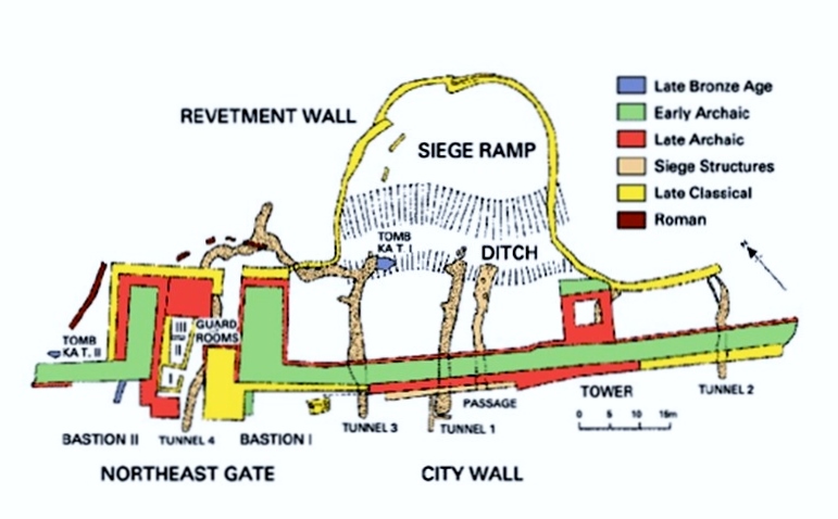
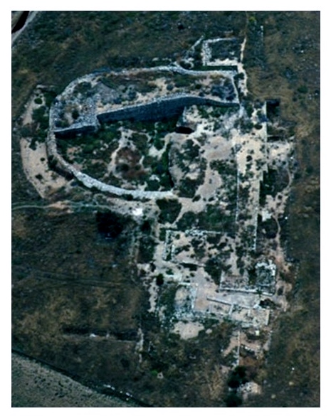
The British Mission: the St. Andrews and Liverpool Museums Kouklia Expedition (1950-1955) After the 1888 investigations at Kouklia by the Cyprus Exploration Fund the area was not revisited for fieldwork excavations for another sixty years. In 1950 a second British Mission resumed excavations at Kouklia until 1955. The Mission was co-directed by T.B. Mitford (University of St Andrews) and J.H. Iliffe (Liverpool Museums) undertook the excavation of several sites within the village of Kouklia and its outskirts. At the plateau of Marcello, the British Mission uncovered a large wall with a dog-leg gate dated to the Cypro-Archaic-Cypro-Classical period, beneath a mound. The massive wall was originally built with sun-dried mud-bricks on a stone foundation. This mud-brick wall was later reinforced by a revetting of roughly-dressed limestone blocks, partly preserved up to a height of 2 m, which gave the wall the massive width of 5.65 m. The dog-leg gate entrance with two massive bastions, projecting from the wall to the North-East, was built with fine ashlar masonry. Sometime during its use three guardrooms were added to the gate court; they seem to have been used as storerooms and kitchens. The British team also excavated a huge bothros which seems to abut the wall to the North. Inside the debris of the bothros more than 1000 fragments of sculpture, hundreds of syllabic inscriptions (some by members of the royal family), a bronze Corinthian helmet and more than 500 bronze and iron arrowheads and spear points were found.The huge horse-shoe bothros was the findspot of the greatest single collection of syllabic inscriptions on stone. All of them have been published by Mitford and Masson. The sculpted pieces and the statuary have not yet been published in their entirety but we have seen enough examples exhibited in our museums and abroad: male figures, sphinxes, lions, cultic capitals, small sanctuaries, baetyls, and the head of a figure deservedly christened the priest king of Paphos and probably also the head of his mortal or immortal consort. According to excavator's interpretation, during the time of the Ionian Revolt (499 BC), the Persian army destroyed an archaic sanctuary that supposedly stood in the vicinity of the wall and used the wreckage to fill in the moat of the city-wall. The Persians then raised a siege ramp against the wall, hence the name "Persian Siege Ramp". At the plateau of Hadjiabdullah Mitford and Iliffe excavated a large and elaborate building, constructed with fine-drafted ashlar blocks, referred to as the "Palace". It consists of many small rooms and narrow corridors arranged on symmetrical axes. The Hadjiabdullah structure was dated to the Late Archaic/Classical period. In addition to the systematic excavations at Marcello and Hadjiabdullah, the British Mission also investigated a number of burials at Kouklia at the localities of Asproyi, Evreti, Kaminia and Skales. In their majority these tombs were preliminarily dated to the Late Cypriot period, a few to the Cypro-Geometric and Cypro-Archaic period. The St. Andrews and Liverpool Museums Mission also excavated mortuary remains from other villages close to Kouklia, at Souskiou-Vathyrkakas and Timi-Sentoutzin tou Rafti. Relevant publications:
|
 |
 |
|
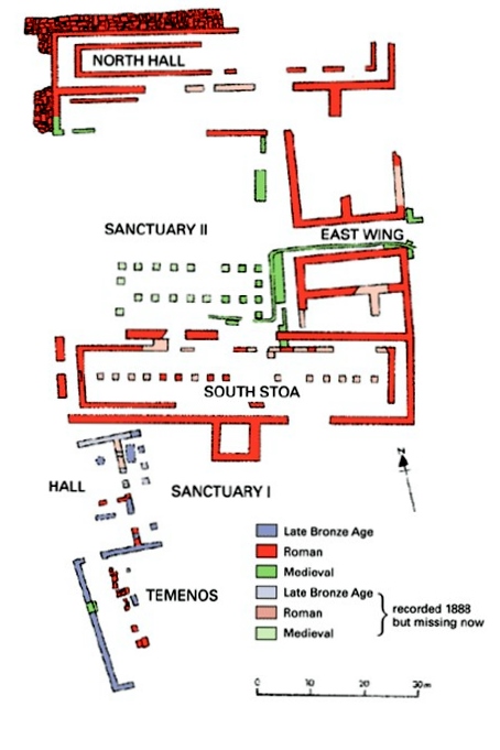
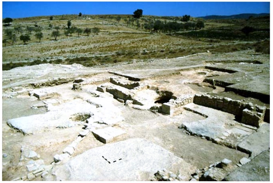
The Swiss-German Mission (since 1966) Fieldwork research was reinstated at Kouklia in 1966, by a Swiss-German team, directed by the late Professor Franz Georg Maier. This Expedition operated under the auspices of the German Archaeological Institute and the Universities of Konstanz (until 1971) and Zurich (since 1972). The Swiss-German team continued the excavation of the Sanctuary (Site TA) between the years 1973-1979. The systematic investigations in the Sanctuary area by the Swiss-German Mission not only revealed an extended area of sacred structures, but also managed to date the Sanctuary's earliest establishment, which was assigned to the beginning of the 12th century BC. The Swiss-German Expedition also investigated the area of Marcello, which was originally excavated by the British Mission during the 1950s. The plateau at Marcello was the focus of archaeological excavations by the Swiss-German team during four seasons: 1966-1969, 1971-1973, 1985 and 1992-1995. The site is referred to as site KA by the Swiss-German excavators. The long-term research in the area revealed a massive defensive wall of Archaic to Classical date. |
 |
 |
 |
 |
 |
| In addition, the Swiss-German Mission investigated the area of Evreti-Asproyi (Site KD/TE), which had also been partly excavated by the 1950's British Mission. The area revealed several Late Bronze Age tombs, together with very limited secular architectural remains and a number of wells, filled with material from residential and industrial (possibly associated with ivory-carving and metalworking) contexts. Amongst the finds of the Swiss-German Mission at Evreti were the architectural remains of a large peristyle house dating to the Classic period.
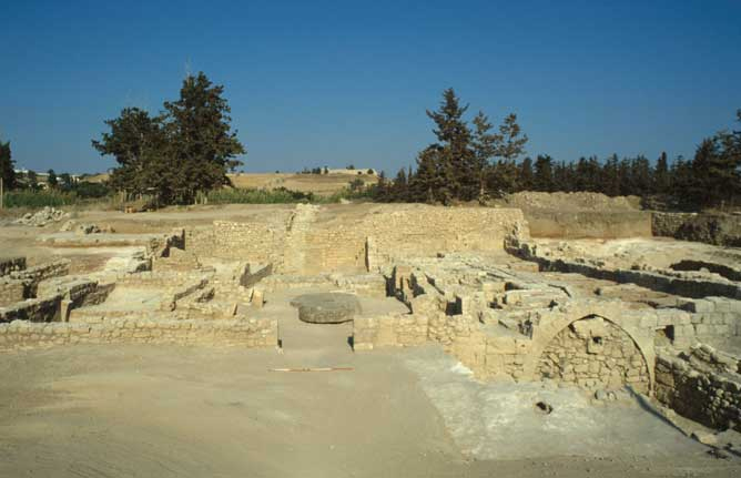
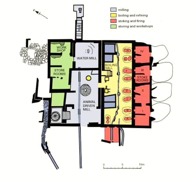
The Swiss-German Expedition was the first mission in Cyprus who initiated a project in industrial archaeology. This involved the investigation of architectural remains and implements pertaining to the sugar-cane industry at Kouklia. Such industrial installations were found in the area of the Sanctuary, which housed refinery building for the production of sugar during the Medieval times. Additional industrial cane-sugar refineries dating between the 13th-16th century BC were excavated at the locality Stavros (Site TST). For the project's website see link |
 |
 |
 |
Selected relevant publications:
|
|
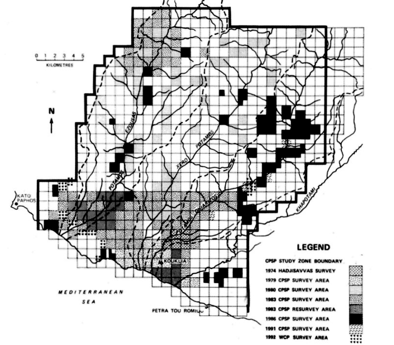
Surface surveys in the wider Paphos area: The "Canadian Palaipaphos Survey Project" (1979-1991) Distinct segments of the greater region of Paphos have been surveyed by the "Canadian Palaipaphos Survey Project" (CPSP), under the auspices of Brock University between the years 1979-1991 and its successor, the "Western Cyprus Project" (WCP) in 1992. Both were directed by Professor David Rupp. In the framework of these two project, the four river valleys of the Paphos hydrological zone (Cha-Potami, Dhiarizos, Xeros and Ezousas) were investigated by means of extensive, semi-intensive and systematic surface collections. Surface surveys were mostly concentrated along the watersheds of Dhiarizos and Ezousas. The "Canadian Palaipaphos Survey Project" and the "Western Cyprus Project" collectively surveyed around 245 km2 of land. Based on these survey inspections, 579 'sites' were recorded around the village of Kouklia, spanning chronologically from the Neolithic period to Byzantine and Medieval times. Selected relevant publications: |
 |
|
Excavations by the Department of Antiquities In 1954 and 1960, the Department of Antiquities, Cyprus excavated architectural remains dating to the Classical period in the area of Mantissa, together with a series of wells filled with Late Bronze Age mortuary debris. In the area of Kato Alonia, on the south slope of the Sanctuary plateau, the Department carried out small-scale excavations within a cemetery. The finds included what the excavator identified as a warrior-grave. Following levelling activities at the site of Skales in 1979, a wealthy cemetery was revealed, that was subsequently excavated by the Department of Antiquities between the years 1979-1980, under the direction of Professor Vassos Karageorghis. The large-scale investigation of Skales by the Department of Antiquities exposed a large cemetery with tombs that extend chronologically from the 11th century BC to the beginning of the Hellenistic period. During the late 1980s rescue excavations in the areas of Teratsoudhia and Eliomylia by the Department of Antiquities revealed significant Late Bronze Age and Early Iron Age mortuary contexts. As a result of the rise in development projects and construction works, the Department of Antiquities has been particularly active in the area of Kouklia during the 2000s. At the localities of Plakes, Skales and Xylinos the rescue excavations of the Department revealed significant tomb-groups spanning the latter part of the Late Bronze Age and the Early Iron Age. At Kato Alonia, the Department of Antiquities brought to light a stone sarcophagus if exceptional craftsmanship, dating to the Cypro-Classical period. The sarcophagus measures 1.99 x 0.67 cm, and it is decorated on all four sides with scenes in low relief and paint. The iconographic repertoire depicted on the Palaepaphos sarcophagus draws inspiration from the Homeric epics: one of the long sides shows the escape of Odysseus and his companions from the Cyclop Polyphemus, the other illustrates the siege of a town, possibly Troy and a battle in which Heracles is the protagonist. The two short sides depict lion attacking a boar, and a hero carrying the dead body of a warrior (possibly Ajax carrying Achilles).
|